By Ben Smith:
The 2020s are pretty medieval. Social media algorithmically shapes “truth” as rumor dynamics did in the middle ages. Nations, corporations, and NGOs vie for influence over the global order like the church, the lords, and local authorities did centuries ago. Our civilizational decline anxiety surrounding late-stage capitalism, climate breakdown, nuclear weapons, and cold war mirrors the medieval end-of-world mindset. Culture today is rooted in nostalgia (“Make America Great Again”, movie reboots, and everybody seems to miss 2016) as medieval culture was rooted in older traditions. Medieval Europeans lived in the shadows of Rome, and 21st century Americans exist in the shadow of the mid 20th century, the height of American hegemony.1 Most egregiously, large corporations are technofeudalistic entities; tech giants own the “land” of data, entertainment, and networks, extracting rent from users who depend on their infrastructure for visibility and income.
In the spirit of the new Middle Ages, this thought experiment explores what a future United States could look like if reorganized into city-state-esque megaregions. In the context of the conservative Project 2025 shock to the separation of powers between the federal government and the states, we can imagine a scenario in which certain power is devolved to more autonomous megaregions. City-states are not new, as “prior to the 19th century… small, self-governing, partly independent political units, comprising a dominant city such as Florence or Amsterdam and their hinterlands, were the norm, the ideal, and the drivers of economic and cultural advances. They combine human scale with economic scope.” In fact, David Brewster of Post Alley reminds us that the Founders were inspired by this model of urban democracy, stating, “autonomous states and proud urban freedoms were conceived as a way to resist an overweening national government by checks and balances.”2
The Medieval European model is gaining some traction today. During the COVID-19 pandemic, US states formed regional alliances to coordinate policy independent of national leadership. In 2025, several Democratic-led states formed regional alliances in response to the RFK Jr.’s political interference with the CDC. Today, Illinois joined a World Health Organization pandemic response network after the Trump administration withdrew the US from the WHO. Members of the European Union are quasi-independent, retaining control over taxation, welfare, defense (mostly), and culture, while pooling authority over trade, monetary policy (for euro states), and regulation.
Paradoxically, the American “party of small government” has expanded executive power under Trump by aggressively utilizing executive orders, bypassing Congress to implement tariffs, ignoring court orders, asserting control of independent agencies, federalizing national guardsmen for domestic policing, and invoking emergency powers (we’re not even scratching the surface here). The erosion of trust in federal institutions could encourage decentralization as cities and states move to govern themselves more assertively. This “new federalism” could evolve as a Plan B to the Trump regime.
The contemporary political geography of states prevents governments from effectively dealing with socioeconomic issues like poverty and inequality. State boundaries are remnants of past purchases, ordinances, and laws and do not reflect the modern US economy, which is made up of megaregions driven by rising urbanization over the last two centuries (roughly 80% of the US population lives in urban areas in 2025). The discrepancy between economic reality and political systems is illustrated in an anti-urban bias Richard McGahey of Big Think describes as “suburbs’ power over zoning, housing, and de facto segregated school systems; and limiting poor urban residents’ access to suburban-based jobs.”
The Texas Triangle, bound by Dallas–Fort Worth, Austin–San Antonio, and Houston, “produces over 75 percent of the state’s GDP and has over 65 percent of the state’s population, but it lacks proportionate political power.” Similarly, “using a technique known as ‘cracking’ — splitting city populations into separate districts — Tennessee is allocating Nashville’s population across three separate congressional districts, all of which observers expect to be won by Republicans.”3 Evidently, the central economic role of cities is not reflected in their political strength. Cities need a stronger governing role in their immediate regions to aggressively enforce racial, social, and economic inequities in housing, education, labor rights, and political representation.
How, then, should the US organize these new city-states? I propose the redrawing of borders to more accurately resemble economic megaregions in conjunction with devolution of certain powers (that’s an issue for another essay). In their 2016 paper mapping the economic geography of the US, Garrett Dash Nelson and Alasdair Rae divided the US into megaregions by treating millions of commuter flows as a network, then identifying clusters where connections are consistently stronger within groups than between them. The authors define megaregions as “large regional areas, often cutting across state lines, that are normally centered on major metropolitan hubs and include an orbit of smaller sub-centers.” Their methodology, both visual and computational, “offers strong evidence that commuter patterns really do divide functionally in space according to the clustering of regional labor markets, and that the structure of ‘megaregions’ can be detected algorithmically.”
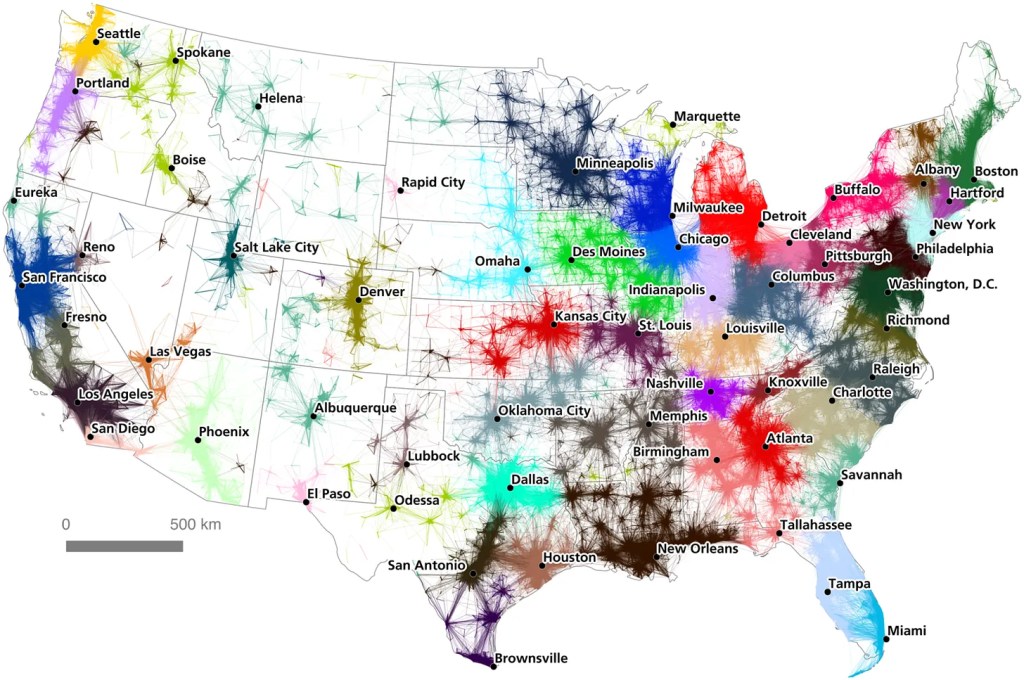
Commuter flow-based regionalization of the United States
Credit: An Economic Geography of the United States: From Commutes to Megaregions
Nelson and Rae posit that by coloring the connections “according to the assigned community of their destination node, we can see cases where neighboring communities are strongly interlinked, and also cases where communities are fairly autarchic in terms of their commuting patterns.” Using their visualized data, they traced convex hulls around the communities assigned by the partitioning algorithm, cleaned up the boundary lines, and produced a tentative map of American megaregions.4
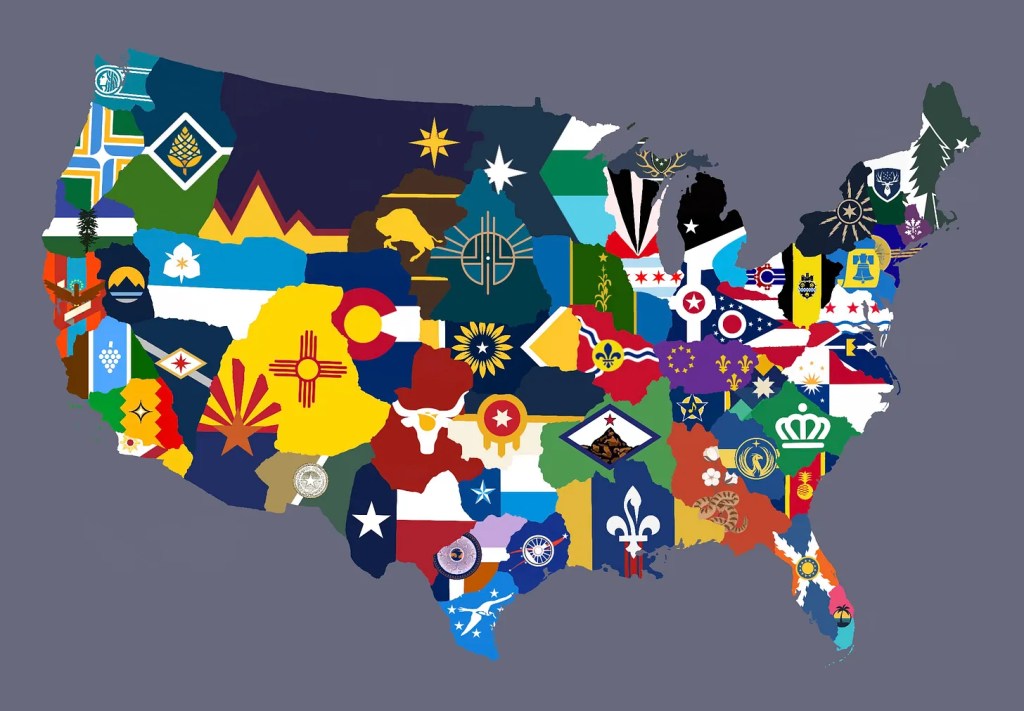
Building on the authors’ approach, I took their finalized megaregion map and filled each region with a distinct flag with the goal of synthesizing a legible geopolitical visual. If the United States is entering a new Middle Ages defined by fragmented authority and technofeudal power, then reorganizing the nation into democratic, economically coherent city-state megaregions may be less a radical break than a necessary return to a political geography that actually reflects how Americans live, work, and govern themselves.

Leave a comment